


West Highland Way classic self-guided walk in eight walking days with luggage transfer
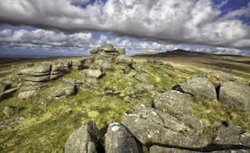
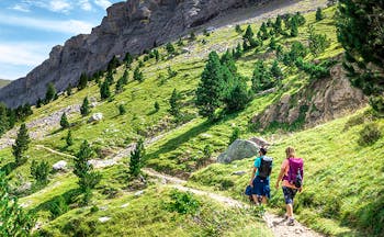
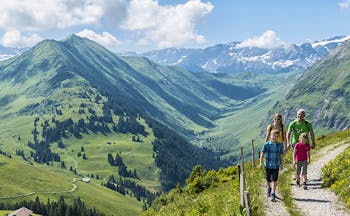
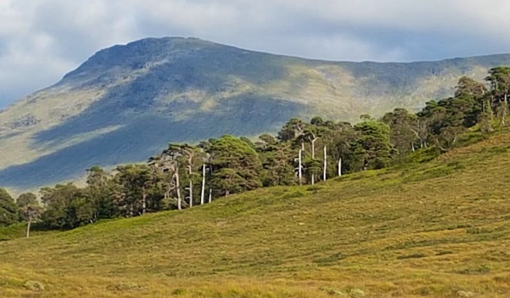
The West Highland Way (Slighe na Gaidhealtachd an Iar), is a glorious route of about 96 miles (154 kms) that stretches from Milngavie on the northern outskirts of Glasgow to Fort William in the Highlands. The route celebrated its 40th anniversary in 2020. Traditionally you undertake the route from south to north, as the scenery and landscape become more rugged and awe-inspiring as you travel north from the relative lowlands of the arable pastures north of Glasgow, along the eastern shores of tranquil Loch Lomond, into the glens of Glen Falloch and Strath Fillan, flanked by mountains now at this stage, and then onto Rannoch Moor, frequently using a mixture of military roads and drovers routes, before glimpsing the austere surroundings of Glen Coe and the sight of Buachaille Etive Mor, and then climbing up what is known as the Devil’s Staircase above Altnafeadh, which at 1805 ft (550 metres) is the highest point of the route before entering the hidden valley of Lairig Mor to reach your goal in Fort William, which is either Nevis Bridge or a more recent statue of a seated walker at the southern end of the town. There is a gradual but distinctive change in landscape as you progress and pass through three areas of great importance to Scottish history: the lands of Lennox, Breadalbane (which covers Loch Lomond and the Trossachs National Park) and Lochaber (of which Fort William is the main town). The path is very well signposted and well maintained with parts being on old cobbled stone military roads, coaching routes and drovers’ tracks. For many parts, the proximity to water is felt by the sight of waterfalls, lochs, streams and rivers as well as the accompanying sounds of water in various stages of flow. Also, along the route, you may glimpse Golden Eagle, Osprey and black and red grouse.
Highlights
Conic Hill • Loch Lomond • Island of Inchailloch • Inversnaid waterfall • Inversnaid RSPB reserve • Falls of Falloch • Ruins of St Fillan’s Priory • Beinn Odhar • Beinn Dorain • Viaducts of the West Highland Railway Line • Loch Tulla • Rannoch Moor • Ba Bridge • Black Rock Cottage • Glencoe Ski Centre • Glen Coe • Buachaille Etive Mor • Glen Etive • Devil’s Staircase • Lairigmor • Dun Deardail Iron Age Fort • Fort William
Walking information
Average of about 12 miles/19 kms per walking day • Average of about 6 hours’ walking per day • Moderate • Moorland, forest, loch side, arable fields • Recommended April to end October
Holiday price guide Sample prices are per person based on two people sharing a double or twin room for 9 nights.
From about
£1,040
Holiday Code CW006
Additional nights can be added before, after or during the tour.
Call us on 01392 441266
West Highland Way classic self-guided walk in eight walking days with luggage transfer
You reach your first overnight stop during the day, perhaps by train from Glasgow to Milngavie and then taking a taxi. Our suggested hotel is about 10 minutes from Milngavie by taxi and you would need to book a taxi to return to Milngavie the next day for the start of the track. Remember to pre-book a table if you want to dine in. Allow time to check your kit, pack your rucksack and study your guides and maps.
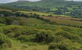
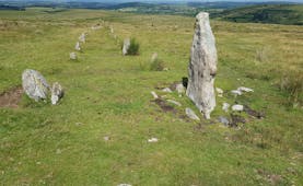
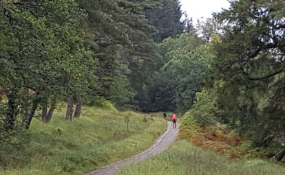
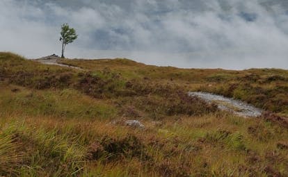
The West Highland Way starts officially in Milngavie town centre before heading into Mugdock Country Park. Today’s terrain is a gentle introduction to the walk with relatively flat countryside and passing some small lochs and rivers before you reach the village of Drymen, not far from Loch Lomond and already perceive the higher land ahead. Even as you leave Milngavie, you are soon in the open countryside of rough moorland and woodland before entering Mugdock Country Park, an important ecological site with species of flowers and oak. Mugdock was the seat of the Graham clan, created Earls of Montrose in 1505 and whose descendant, the Great Montrose, was a military strategist for King Charles I. You pass Craigallian Loch and then Carbeth Loch, and then soon after the track rises and you are on the cusp of a different landscape, passing from the tame to the rugged as you see the Campsie Fells and the Strathblane Hills. This is an introduction to what is ahead although you are still in the Lowlands with the boundary with the Highlands being ahead. You catch sight of the most southerly of the Munros, Ben Lomond and in the distance, although probably unfamiliar if this is your first time on the West Highland Way, are the Crianlarich Hills. You skirt the volcanic plug of Dumgoyach and to the right you can see the Dumgoyach Standing Stones, dating from prehistoric times. Here you’re passing through open pastures before joining a track that is the line of a disused railway, the Blane Valley Railway, which opened in 1867 but closed in 1959. At the site of the former Dumgoyne railway station, the Beech Tree Inn offers refreshment. At Gartness you leave the railway line and follows a country lane that nevertheless has traffic on it, which then descends into Drymen. Drymen is a charming village with a range of facilities and a choice of places to stay. It used to be a stopping place for cattle drovers and is centred around a village green, unusual for Scottish villages. Not far from the village is the ruined Buchanan Castle, owned by the Duke of Montrose and which housed Rudolf Hess in World War II.
Distance: About 12 miles (19 kms)
Time: About 6 hrs
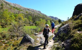
Ahead of you today is Loch Lomond and the boundary between the Lowlands and the Highlands, marked by a chain of islands across the Loch. You have your first encounter today with a Scottish hill, that of Conic Hill at a height of 361 metres. Initially the track veers through open fields and forest affording pleasant walking particularly through Garadhban Forest as the track undulates with blue-toned hills ahead that come and go from view. After a while you see Loch Lomond and its islands with Conic Hill to the right. Crossing bracken and heather-covered moorland, the path heads for Conic Hill and rises to give views of Ben Lomond, the Loch, the Luss Hills and in the distance, Ben Vorlich, Ben Vane, Ben Ime and Ben Narnain. Conic Hill too sits right on the divide between the Lowlands and the Highlands, which runs from Arran in the west to Stonehaven in the east. The path descends steeply and continues to afford splendid views. Then it’s through a woodland path to Balmaha on the edge of Loch Lomond. The Oak Tree Pub and café serve food and drinks, right on the shores of the loch. After Balmaha, enjoy the tranquillity of the loch and the view of the islands in its midst. It’s possible here to spot Ospreys as they dive into the loch for fish. Then the track ascends before descending again and you reach the water’s edge passing shingle beaches and fields until you reach Milarrochy with its visitor centre and car park. From here to Rowardennen, the track is never far from the side of the loch, sometimes heading through woodland of pine and sometimes joining the road from Milarrochy to Rowardennen. There is some undulation and views of Ben Lomond before you emerge from rhododendron bushes to reach Rowardennen. The tarmac road stops here.
Distance: About 15 miles (24 kms)
Time: About 7.5 hrs
Today’s section of the route covers the northern, more remote section of Loch Lomond, with the terrain being more challenging and the sense of wilderness much more enhanced, particularly north of Inversnaid. Between Rowardennen and Inversnaid the track is mostly forestry track which gives way to a more demanding, up-and-down route along the side of Loch Lomond. You are now entering the lands of Clan MacGregor and a crag on the side of the loch before Rowchoish is known as Rob Roy’s Prison. From here the track is a broad, forest trail before becoming a woodland pathway amongst trees of oak, birch and pine. You continue on the track, not far from the loch, and in woodland until you reach Inversnaid, where there is a hotel and an attractive waterfall. The area here is renowned for its wealth of birdlife. From Inversnaid to Inverarnan, the section has a reputation as being the toughest of the whole walk, mainly because of the combination of ascents and descents with rocky ground underfoot also, because it is remote and rugged. Just before Doune the track opens up. Doune with its farmhouse and bothy is a popular spot to rest. At Ardleish Pier the track leaves the proximity of the loch shore and rises away from the loch to Cnap Mor and then down into Glen Falloch. At Beinglas Farm you need to track towards the A82, crossing the River Falloch, and back along the road (there is a footpath) for the accommodation for tonight.
Distance: About 14 miles (22.5 kms)
Time: About 7 hours
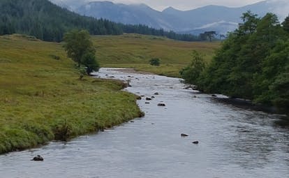
You need to return to the track but essentially today you enter a different landscape: one of soaring mountains and gentle glen walking, often following the route of the old military road and with easy ascents and descents. You follow the River Falloch through the glen, glimpsing the Falls of Falloch and noticing as you pass up the glen, that there are more and more isolated pine trees. These are remnants of the great Caledonian pine forest that dates from the last ice age. Not long after Derrydarroch the route passes under the railway line and then passes under the A82 by a tunnel that leads to the old military road. This then heads towards Crianlarich, where you might want to take a break. The military roads date from the mid-18th century and were devised by General Wade and whose construction was overseen by Major Caulfield. After a pause at Crianlarich, you return to the old military road, which undulates but gradually gains height affording views over Strath Fillan to Ben Challum. The path continues through a mixture of woodland and greenery, crossing the A82 again, taking a bridge over the River Fillan, towards Kirkton Farm and St Fillan’s Priory. This was probably a 12th century monastic site dedicated to the memory of St Fillan in the 8th century. However, a short distance along, after crossing the Allt Auchtertyre you rejoin the A82 near the Holy Pool, which was probably the original site of St Fillan’s Priory. You follow the path parallel to the river, until it crosses the Crom Allt by a wooden bridge near the site known as Dal Righ, or ‘the King’s Field’. This is where Robert the Bruce is said to have battled with the MacDougalls of Lorne and was defeated. From here there is shortly a stony footpath that rises to pass a small lochan. This is known as the Lochan of the Lost Sword, after a legend that tells that Robert the Bruce tossed his sword into the water after his defeat at Dal Righ. You pass through more woodland just before reaching Tyndrum. Tyndrum, meaning the ‘house on the ridge, was a popular location for cattle drovers in the 18th-and 19th- centuries.
Distance: About 12 miles (19.5 kms)
Time: About 7 hours
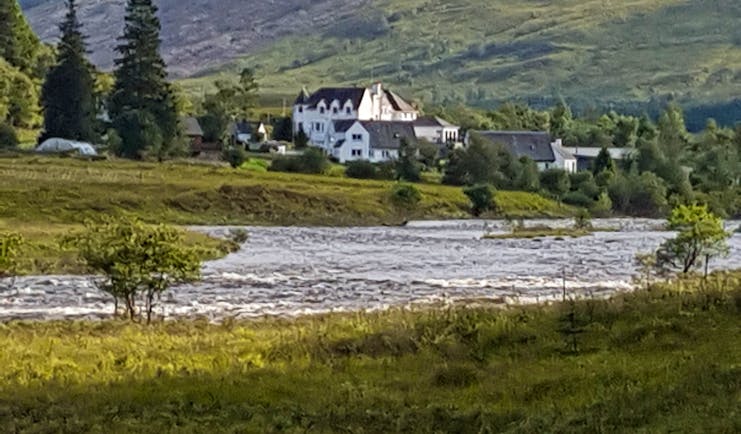
The West Highland Way site advises the walker that there are no more shops after Tyndrum until Kinlochleven, 28 miles away, so you might want a later start today after stocking up on any necessary supplies. From Tyndrum you start to feel the full force of the mountainous landscape and archetypal Highland scenery. Between here and your destination tonight at Bridge of Orchy are plantations of trees and fields for rearing cattle and sheep. Your track skirts the sides of Beinn Odhar and you spot the pyramid of Beinn Dorain ahead. You descend into the open Auch Gleann with a clear path ahead and never far away is the silhouette of Beinn Dorain. Ahead is Bridge of Orchy with Loch Tulla in the distance. You arrive at your hotel today with plenty of time to relax and take stock of the route covered so far.
Distance: About 6.5 miles (10 kms)
Time: About 3 hours
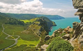
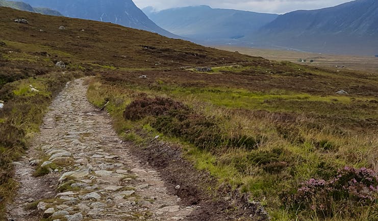
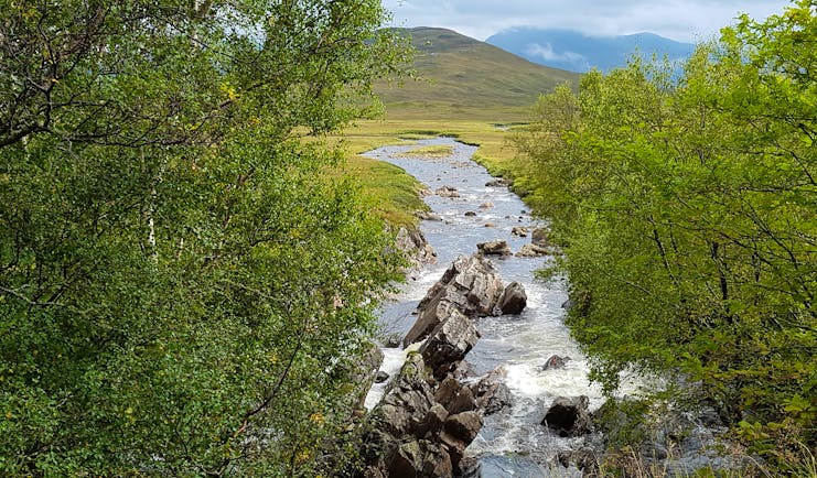
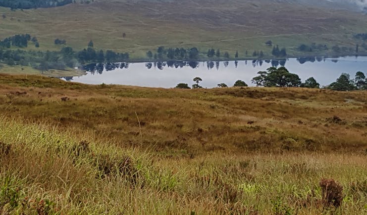
Today’s route is one of the most dramatic and memorable of the West Highland Way, affording wonderful vistas of water, sky, moor and mountain, the constant sound of running water and a tremendous sense of open, natural space. You become acquainted with Loch Tulla, Ba Bridge, Rannoch Moor, Blackrock Cottage, Buachaille Etive Mor and Glen Coe. Part of the way is on forest track and much is on the cobbled stones of the old coaching road and the military road. Rannoch Moor is exposed but the walking is relatively straightforward. Just ensure you have adequate clothing for inclement conditions. Cross the stone bridge over the River Orchy and take the path that ascends away from the road towards woodland. The track is easy going but it climbs, although not over-strenuously and winds its way through trees and across moorland. As you emerge from the trees you see Beinn Dorain and Beinn an Dothaidh to the east. The route is the old military road again here. The grassy hillsides are swathed in purple heather. As the route crosses the side of the hill, a large cairn provides an excellent viewpoint of Loch Tulla as well as Forest Lodge and the mountains ahead. From here you descend easily to the tarmac road at the Inveroran Hotel. You take the road from here passing a wild camping site to Forest Lodge, once a hunting lodge but where the route leaves the military road and instead, follows the old Glen Coe road, which is cobbled. Ahead is Black Mount and Rannoch Moor, replete with heather, bracken, rivers and burns. Lochs of varying sizes are studded across the landscape. The route climbs steadily but there are ample places to stop, rest and admire the scenery with low, stone bridges that cross the streams. Never far away is the sound of gurgling or rushing water. One of the most dramatic places to experience the rushing of water is at Ba Bridge, where the water is forced through rocky boulders at great speed. As you cross Rannoch Moor keep an eye out for the wildfowl that visit this patchwork of lochs and lochans including black-throated divers, red-throated divers and greenshanks. After Ba Bridge, the track ascends as it curves around the sides of Meall a’Bhuiridh and climbs to a height of about 450 metres above sea level, before descending below the White Corries to reach Blackrock Cottage and the A82. After the high point you are faced with a change in the landscape. The relative softness of the moor is behind you and ahead are the mountains of Glen Etive and Glen Coe. The last stretch of the route today is on the other side of the A82 as you descend towards Kingshouse at the end of Glen Coe and with the striking outline of Buachaille Etive Mor ever visible.
Distance: About 12 miles (19 kms)
Time: About 6 hours
Buachaille Etive Mor which translates as the Great Herdsman of Etive is one of Scotland’s most famous Munros and sits at the entrance to Glen Etive and Glen Coe. With Buchaille Etive Mor on your left you track alongside the A82 in the direction of Glen Coe until at Altnafeadh you turn sharply right, enter grass and heather moorland and then encounter the zig-zag path that is known as the Devil’s Staircase which gains height steadily. This takes you up to the highest point of the West Highland Way at 550 metres and marked by a cairn. There are spectactular views back to the Buachaille and north to the Mamores mountain range. From the summit the track meanders across moorland before descending to Kinlochleven, in a valley at the end of Loch Leven.
Distance: About 9 miles (14.5 kms)
Time: About 4.5 hours
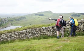
Your final day begins with a steep climb out of Kinlochleven which does provide sweeping views along Loch Leven and back to Kinlochleven. Your immediate goal is Lairigmor (the Great Pass) which provides easy walking in the wide pass, the preserve only of walkers and estate workers, between steep-sided mountains including Mam na Gualainn and Beinn na Caillich. The military road offers steady and easy walking, allowing you to view the Munros behind Ballachulish and the ridge of Aonach Eagach. In Lairigmor you’ll pass ruined crofts, a reminder of a former way of life in these mountains. before heading towards Glen Nevis, leaving the military road near Bla a’Chaorainn. The route continues through forestry plantations before Britain’s highest mountain, Ben Nevis, is visible. A glen to the south-west of here contains Lochan Lunn Da-Bhra which is where Macbeth, King of the Scots from 1040 to 1057, is said to have resided. Legend also has it that the lochan is inhabited by a monster that leaves the water to kill grazing animals. The final stage from here is through extensive woodland and is rougher than you might like at the end of the walk, but the route descends down into Glen Nevis and joins a road for the last stretch into Fort William. Take time to marvel at the bulk of Ben Nevis as you approach Fort William or digress from the track to visit Dun Deardail, an Iron Age fort. Tradition has it that on arrival in Fort William walkers who have completed the West Highland Way head for Gordon Square and the chance for a photo alongside the bronze statue of a fellow walker.
Distance: About 15 miles (24 kms)
Time: About 7 hours
Holiday price guide Sample prices are per person based on two people sharing a double or twin room for 9 nights.
From about
£1,040
Holiday Code CW006
Additional nights can be added before, after or during the tour.
Our prices include
● Accommodation in a double or twin room on bed and breakfast
● Packed lunch every day except day of arrival
● Luggage transfer between hotels
● Guidebook and our walking notes
Call us on 01392 441266
Holiday price guide Sample prices are per person based on two people sharing a double or twin room for 9 nights.
From about
£1,040
Holiday Code CW006
Additional nights can be added before, after or during the tour.
Our prices include
• Accommodation in a double or twin room on bed and breakfast
• Packed lunch every day except day of arrival
• Luggage transfer between hotels
• Guidebook and our walking notes
The journey and how you get there
The official start of the walk is in Milngavie with our suggested hotel being in Strathblane, about 10 minutes away by taxi. If you would prefer to book your own accommodation in Milngavie then we can take out the first night’s accommodation from our itinerary. We would need to know where you are staying for the luggage transfer. Milngavie can be reached by train from Glasgow Central Station in just over 20 minutes.
We do not include taxis but can provide contact details for taxi companies. Also, if you need a taxi during the walk (which may be required depending on where you stay), your hotel will be able to arrange it for you. Luggage transfer is included from hotel to hotel for you for up to two items of luggage.
Call us on 01392 441266
West Highland Way classic self-guided walk in eight walking days with luggage transfer
About Great Britain
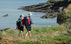
The countries of Great Britain, England, Scotland and Wales, provide a wealth of beautiful and interesting walking terrain. Within a relatively small area there is a richness of diversity of geography and topography, peoples and dialects, local architecture and traditions and a rich history that has been world-facing and world-interacting for thousands of years. The landscape of this small island varies every few miles, with dales and vales, moors and coastline never far away and here and there you find proud post-industrial cities, flourishing cathedral cities, gentle market towns and picturesque villages, perhaps with a village green, pond, cricket pitch and ancient church, as well as the local pub. Traditions of local heritage feature strongly with festivals and pageants, local arts and crafts and artisan produce. There are many National Parks and designated walking paths. There are recognised coast to coast walks such as the Two Moors Way from the English Channel to the Atlantic Ocean, or the Coast to Coast walk in northern England; there are walks that cover historic landmarks such as Hadrian’s Wall; there are walks that introduce the rambler to the awe-inspiring natural landscape of lakes and mountains such as the West Highland Way; there are walks that hug the dramatic coastline of Great Britain such as the South West Coastal Path or the Northumberland Coast Path. Ordnance Survey maps provide support from not just contours and terrain but historic and noteworthy points of interest too. Within many walks of just a few miles, the rambler will experience a delightful variety of terrain, aspect and vegetation.
Facts in brief
Capital LondonAirport London Heathrow, London Gatwick
Size 209,331 sq km
Population 64.55 million